
Enter our Second Chance Contest for a chance to win a $25 Digital Visa Gift Card.
Everyone can enter — even if you submitted a prediction in the original contest.
ENTER THE SECOND CHANCE CONTESTEntries accepted until the B.A.A. announces the 2027 Boston Marathon qualifying cut-off time.

Compare two marathons side-by-side: course difficulty, elevation, typical race-day weather, finishers, BQs, and runner reviews—so you can choose the right race for your goals.
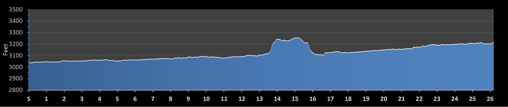
The Missoula Marathon delivers a highly scenic, flat, and fast point-to-point course that accommodates both PR chasers and Boston Marathon hopefuls. While the route is predominantly flat with a total elevation gain of under 500 feet, its overall difficulty is influenced by a baseline altitude above 3,000 feet and a single, significant climb situated near the midway point of the race.
The USATF-certified and sanctioned course features a paved, all-road layout that guides runners through shifting environments. The race begins in the rural Montana countryside of Frenchtown, proceeding along long, straight stretches cutting past agricultural fields and the Clark Fork River valley. As the race progresses, it enters the urban limits of Missoula, transitioning onto tree-lined residential streets before concluding in historic downtown Missoula at the Higgins Avenue Bridge (Beartracks Bridge).
The defining section of the race arrives just past the halfway mark, where runners tackle the course's main hill, climbing from roughly 3,100 feet to a peak of 3,256 feet. This elevated stretch provides panoramic river views and a descent that follows immediately after. Once past the hill, runners enter local neighborhoods where the layout incorporates numerous turns. While the opening rural miles are highly exposed to the morning sun with minimal shade, the later residential sections feature helpful neighborhood crowd support, including community-placed spectators and hose stations.
A smart pacing strategy requires keeping an even, controlled effort through the long, exposed straightaways of the first 13 miles and conserving energy for the midway climb. Because the sun can warm the valley rapidly at this altitude, banking time early often leads to late-race fatigue on the twisting neighborhood streets. The course is an ideal fit for runners seeking a community-backed mid-sized event that balances peaceful countryside miles with an energetic downtown finish.
| Max Elevation: 1456 feet (443m) |
| Min Elevation: 1402 feet (427m) |
| Max Elevation: 3263 feet (994m) | Elevation Gain: 492 feet (150m) |
| Min Elevation: 3037 feet (925m) | Elevation Loss: 315 feet (96m) |
 (4.6)
(4.6)